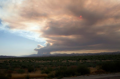
On Monday, 6 Aug. 2018, an arsonist lit fire in Holy Jim Canyon, which quickly spread, and two weeks later burnt 22,986 acres. Since then, flareups have occurred within the burn perimeter.
(Photo: Holy Fire on 6 Aug 2018.
I consider this the most expensive solar filter I've ever used.)
A local politician found the opportunity to remind us that the damages from this fire are a result of unchecked mental health issues in our society:
Lake Elsinore Councilman Bob Magee on the fires of mental illness
While unhinged persons are a threat, and such persons started two recent conflagrations in Riverside County, Magee's argument downplays the contribution of climate, weather, and topology in making fire devastating, whether it starts by arson or by accident.
Interior Secretary Ryan Zinke has suggested that
environmentalists are to blame for not allowing forest thinning, claiming that an increase in fire severity is due to a build up of dead trees. In the case of the Holy Fire, steep terrain and abundance of chaparral makes thinning difficult. It's also not clear to me how thinning operations would make forests less prone to fire. Heavy equipment, for example, disturbs undergrowth, promotes erosion, and invites invasive weeds that can make fire more likely.
Yet others, suggest that California's governing political party is to blame for severity of recent wildfires. It's unclear to me how State Officials can be directly responsible for management of Federal forests, but that doesn't stop any finger pointing.
To examine the connection between dead trees and fire, I superimposed a map of the Holy Fire on a Forest Service map of tree mortality. It shows little correlation between the Holy fire and dead trees:
Note that the large pink area on the left is a Tier 2 hazard zone defined by the Forest Service. I believe this definition is based on threat to a region such as a watershed. So, in this zone, should a fire break out, it will likely not be contained till it reaches the perimeter of the watershed. Combined with the presence of high-density tree mortality, this warrants a Tier 2 designation. At least, that's how I interpret the map, yet, there is something odd about tree mortality maps. They are based on aerial surveys from 2012-2017, but close-ups of the region show mostly oak woodlands, chaparral and riparian canyons. So, it is not clear to me how how these fire designations are determined -- a project for further research
jg
Links
https://patch.com/california/lakeelsinore-wildomar/op-ed-ignoring-fires-mental-illness-we-need-change
Tree Mortality Viewer
CalFire Incident map
Hotter weather turbocharges US West wildfires


