Showing posts with label geology. Show all posts

Friday, May 1, 2015

Rock Rings (from December 2014)

I have a new puzzle to sort out. Last December, I examined some rocks in a nearby canyon that where covered by silt, but had rings at various former water levels. The rings are levels on the rock that got cleansed, while the rest of the rock is covered with a fine layer of sediment as the water receded. What mechanism would cause the selective cleaning?


My guess is that as the water slowly receded, it would deposit sediment on the rocks. Then, if the rain resumed, we might get a freshened surface layer of water that would cleanse the rocks. The puzzle is how an increase in rain would remain less silty than the rest of the flow. It seems logical: the first rains loosen most of the material that becomes silt, and later rains loosen less. But the water has to flow down the canyon, so any turbidity would be stirred up by the freshened flow. But it seems reasonable that an increase in flow with fresher water at the surface could clean the rocks and leave clean rings.


Other photos:

Suds formed, a presume from natural elements.

Typical muddy flow as canyon drains and water levels drop.


More rings with debris deposits.

jg


Wednesday, October 23, 2013

Would I notice a rock slide if it were right in front of me?

I once emailed a link to one of my climate illustrations and told the recipient, "make sure you read the caveats tab." She replied, "everyone should have a caveats tab."

And so I continue to look for opportunities to test what I know, as well as what I remember.

Two years ago I started exploring a hiking route that involves some rock climbing and a lot of scrambling. Think if it a course of constant deep knee bends and limbo manuvers. After about a half year of exploring this route I noticed a rock slide:


This hike is in a canyon with a lot of loose rock and rapidly eroding slopes. Therefore, I stay away from these hazards. But still, I always look at where I walk and observe my surroundings, and I should have been looking out for something so obvious a hillside of newly exposed rock and dirt. Or would I notice such a thing?

Did I witness a significant erosion event in the short time I'd been exploring this canyon? Or did I fail to notice something that occurs on a longer scale? -- and therefore, need to examine my observation skills for overconfidence.

This rockslide also knocked over a cotton wood tree. Here is a photo of it sideways on the ground with a new shoot growing upright.


The photo above shows dead limbs (angled downward) and a new limb (angled at 2:00 ) which is actually vertical, though this isn't obvious in the photo. In fact, the tree had about a half dozens of these newly started vertically growing limbs. The presence of new vertically growing limbs when the rest of the tree is horizontal offered a proxy measurement of the date at which this tree was suddenly knocked over.

I selected one of the thickest limbs (the one in the photo above) and cut off a sample of the limb near the base. Below, I've counted and labeled the growth rings. I count three more than the time I've been visiting this rock slide.


So, I add this to my metaphorical caveats tab. I can miss the obvious. Do others?

jg

Tuesday, July 2, 2013

Rock Weathering Post on Skeptical Science

John Mason of Skeptical Science has written an excellent overview of long term rock weathering and how it maintains atmospheric CO2 levels. I contributed a sketch on the post in which I tried to stuff every relevent component of the long term carbon cycle into a width of 560 pixels. I also created larger versions that are available in the Skeptical Science Climate Graphics section.


jg

Saturday, May 19, 2012

Volcanoes, CO2 and Temperatures

A friend has prompted me to post for reference a couple illustrations I've created for www.skepticalscience.com on estimates of emissions of CO2 by volcanoes. It is a common belief that volcanic activity produces more atmospheric CO2 that human activity, however, research shows that in the modern era, volcanoes haven't been active enough to account for the steady rise in CO2.

The first chart compares surface temperatures by the Goddard Institute for Space Studies with atmospheric CO2 and stratospheric optical thickness, which is used as a proxy for volcanic activity.

The second illustration summarizes the conclusion of Terry Gerlach of USGS publishing in the Transactions of the American Geophysical Union: Volcanic vs Anthropogenic Carbon Dioxide, EOS, 14 June 2011).


In the above diagram, the area of the clouds correspond to the emissions of each source.
jg

Tuesday, April 19, 2011

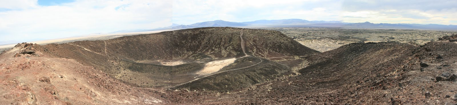
Amboy Crater: 50 minutes North from my last post

Twenty-one years ago I drove across the great plains and southwest deserts of the United States on my way to California. Iraq had just invaded Kuwait and gas prices soared. I made a note of the highest price: $1.79 per gallon in Amboy California, which is near the southwest portion of the mojave desert. While in Amboy, I noticed a lava flow and prominent cinder cone and vowed to return. Twentyone years and over 2 dollars per gallon later, I returned.

Amboy Crater, viewed from the western rim (spliced together from three photos)


The drive north from Joshua Tree National Park to Amboy crosses classic alluvial fans. These alluvial features evelope the base of the mountains and form vast gradual slopes where you can drive for miles, barely noticing any elevation change.


The cinder cone rises 250 feet from the surface, making it unmistakable:

A mile-long trail leads from a parking lot to the cone and crosses the lava flow and it's varying features. Here, the flow's low, wavy shape is highlighted by the dry grass:


And here the texture is that of a pushed up parking lot, rock black as asphalt and cracked. Plants and sand exploit the cracks.

The composition of the cone has texture differences. Right is crumbly; and left, more of a charcoal color and texture comparable to graphite powders. The left also has distinct erosion channels.


A view looking down from the crater rim near the transition between textures.


A close up of the texture change:


After my visit, I found Amboy Crater on GoogleEarth, which is just like being there, unless of course, you've actually been there.


Notice the satelite photo from GoogleEarth shows streaks from the cinder cone and other features. These streaks weren't apparent to on the ground, and if they are real, my guess is that the streaks are wind deposits, darker grains blown from the cinder cone and other outcrops, and deposited onto the sand dusted flow. It is likely the winds blow consistently to the south east, something to follow up on.

Something on the sparse wildlife:

A very unusualy insect, unless I presume, you live here.


And a few plants:

Possibly a mallow or type of lilly growing among the lava rock -- another plant to identify.

Bright yellow encelia bushes peak around March and make a delightful contrast with the dark rock.

One last note: The best time to visit is Oct - March when the temperatures are mild. The lava flow heats up in the sunlight and would be dangerous for most people to cross when April-Sept temperatures start in the 90s.

jg