As of Dec. 20, 2016, Mick Mulvaney is President-Elect Trump's choice for Director of the White House Office of Management and Budget. The Management side of the OMB is concisely stated on its website:
OMB oversees agency management of programs and resources to achieve legislative goals and Administration policy. (https://www.whitehouse.gov/omb/management)
Their website has a much longer, but thorough description of the Budget by policy objectives. These objectives range from creating a climate-smart economy, protecting and increasing water supply, crop insurance, preserving and protecting public lands and oceans, revitalizing manufacturing, biomedical research, civil space, agriculture, education, protecting workers, tax reform, health and safety, justice system, immigration, border security, terrorism, Russian aggression, humanitarian needs.... (https://www.whitehouse.gov/omb/budget)
Thursday, December 22, 2016
Wednesday, December 7, 2016
CO2 in the Air and Oceans
At Skeptical Science we started some general posts based on questions from readers. I think it's a good service. Someone asks a reasonable and thoughtful question and gets a custom essay which may include illustrations. Or first in a series is here:
(I put a diagram and an animation in this post illustrating long term storage of CO2 in the oceans.)
jg
(I put a diagram and an animation in this post illustrating long term storage of CO2 in the oceans.)
jg
Tuesday, November 29, 2016
A letter to President-elect Trump
In the spirit of working with the President-elect, some of my international friends and I have linked the following individuals to Trump's Chinese global warming conspiracy:
Though there are many more individuals to be outed, we stopped at those doing their work before Trump was old enough to find conspirators on his own. Writing in the now foreign language of fact and reason, my friends argue that climate science is a proud accomplishment of Western civilization:
I'm backing them with this illustration:
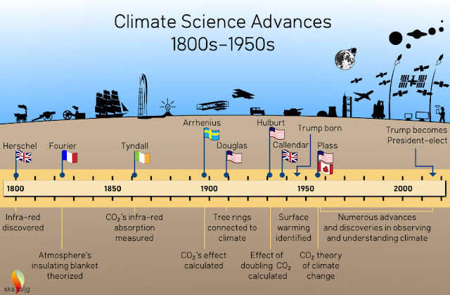
- Englishman William Herschel,
- Frenchman Joseph Fourier,
- Anglo-Irishman John Tyndall,
- Swede Svante Arrhenius,
- Americans Andrew Douglass and E.O. Hulbert,
- Englishman Guy Callendar, and
- Canadian-American Gilbert Plass.
Though there are many more individuals to be outed, we stopped at those doing their work before Trump was old enough to find conspirators on his own. Writing in the now foreign language of fact and reason, my friends argue that climate science is a proud accomplishment of Western civilization:
I'm backing them with this illustration:

Sunday, November 13, 2016
Western Riverside Council of Governments LED Light Tests
The Western Riverside Council of Governments is sponsoring a test of LED light fixtures considered for widespread use throughout western Riverside County. The new LEDs offer great improvements on energy consumption, aiming, and intensity control, but vary in how well they minimize light pollution, preserve a night-time ambiance, and disrupt circadian rhythms of humans and animals. Understanding the wavelengths of light, which humans perceive as color, is key to selecting lights that minimize negative effects.
WRCOG is sponsoring tours of the test lights. About a dozen manufacturers provided sample LED lights that were installed in various settings in the city of Hemet. Installations include commercial, roadway, and residential sites. The tour participants are invited to rate how they safe they feel and how well they see under each light as well as how much they like the aiming (e.g., you may like a light but not want it spilling into a your bedroom window, or maybe you would like it to spill a little into your front yard). Participants were discouraged from looking at each light directly and were not told of the lights' exact specifications on color temperature. I was a flawed participant because I was to eager to assess the glare and spectra of the lights for their impact on the night sky. My interests required looking directly at the lights and testing their output with my spectograph:

A key specification in understanding the impact of a type of light on the night sky, and therefore, on Palomar Observatory and our ability to enjoy the night, is color temperature. Color temperature comes from the physics concept of black body radiation and is used to describe how a given unit of mass radiates energy when heated to different temperatures. If I took a chunk of matter and heated it to 2700 K, 4500 K, and 6000 K and measured the wavelengths of light emitted at each temperature, I'd have data similar to the following:

So, an object that is at 6000 degrees Kelvin (6000 K) will put out radiation all across the electromagnetic spectrum but the wavelengths at which it emits the most energy will be at the green part of the color spectrum. 6000 K is approximately the temperature of our sun, and its peak output is in the green wavelengths, but since our eyes are adapted to the full range of color produced by the sun, we perceive the sun's light as white. Any lamp matching the sun's output we will perceive as white and the color temperature specification would be 6000 K. If you see a light that has noticeably more blue color, like with some plasma TV screens, you might infer that it's color temperature is higher than 6000 K, perhaps 7000 K or 8500 K.
The blue spectrum of light affects human and animal health. More of it at night, when the body is trying to shut down for sleep, will disturb the natural production of hormones that regulate our health. That is why the American Medical Association has recently issued warnings about the wide spread adoption of lighting that peaks in the blue part of the spectrum. The blue end of the spectrum also scatters more readily in our atmosphere, and therefore, it creates more light pollution than lights on the red end of the spectrum. Consider a common observation, the sky is blue on a clear day and red at evening and sunrise. This is because the blue light gets scattered and the red light beams straight or bends only slightly. So, lights with a lot a lot of blue will be scattered back at us, creating for us the look of a gray sky with few stars. We see this effect on cloudy nights when the clouds reflect most of the light back to us and our bedroom windows glow with this light pollution.
Below is a light on WRCOG's test. I was impressed based on my visual observation. The color is similar to the color of low-pressure sodium, but offers more color rendition and is very well aimed, hitting the street only. But when I looked that the lights through my spectrograph, I was reminded that the real test will be scientific measurements of the lamp's spectra.

Below are two light spectra measured by Dan McKenna of Palomar Observatory. All I know about the specific lights are their designations within the test program (P104 and P46). I've added some annotations:

The photo composite below shows a comparison of three lights. The top and bottom are new LEDs that differ in the range of color produced. Both are rated at a maximum of 3000 K though I suspect that this rating doesn't accurately reflect the blue light in the bottom example.

This residential street corner provides a reasonably fair comparison of new LED to existing LPS:

This row of distant lights demonstrate that it's easy to aim the new LEDs. You see less flare from the new lights because most of the light is directed downwards.

The type of lights chosen now will have a great impact on our night sky. All offer excellent opportunities for energy savings, aiming, and dimming, but some will produce wavelengths that will take away some of the pleasant qualities of the night. I am, of course, biased, because I consider the night sky a key feature in my quality of life. I've learned to see well in low lighting by relying on my night vision. I've also learned that though you can perceive color better in white light, such lighting doesn't make me see detail better. But what is important to me may not be important to others, so it is important for others to participate in these tours to offers their opinions. I welcome diverse opinions here and will preserve any comments.
jg
Other references:
National Academy of Sciences: Evening use of light-emitting eReaders negatively affects sleep, circadian timing, and next-morning alertness
American Association for the Advancement of Science: Can't Sleep?
Light Spectra with caption for distribution:

WRCOG is sponsoring tours of the test lights. About a dozen manufacturers provided sample LED lights that were installed in various settings in the city of Hemet. Installations include commercial, roadway, and residential sites. The tour participants are invited to rate how they safe they feel and how well they see under each light as well as how much they like the aiming (e.g., you may like a light but not want it spilling into a your bedroom window, or maybe you would like it to spill a little into your front yard). Participants were discouraged from looking at each light directly and were not told of the lights' exact specifications on color temperature. I was a flawed participant because I was to eager to assess the glare and spectra of the lights for their impact on the night sky. My interests required looking directly at the lights and testing their output with my spectograph:

Photos taken with my spectrograph of a low-pressure sodium light (top)
and a new LED (bottom two)
A key specification in understanding the impact of a type of light on the night sky, and therefore, on Palomar Observatory and our ability to enjoy the night, is color temperature. Color temperature comes from the physics concept of black body radiation and is used to describe how a given unit of mass radiates energy when heated to different temperatures. If I took a chunk of matter and heated it to 2700 K, 4500 K, and 6000 K and measured the wavelengths of light emitted at each temperature, I'd have data similar to the following:

Diagram produced with my home-made Planck black body radiation curve generator
which is available on line at my website. See Planck Viewer,
and ask here if you need help using it.
So, an object that is at 6000 degrees Kelvin (6000 K) will put out radiation all across the electromagnetic spectrum but the wavelengths at which it emits the most energy will be at the green part of the color spectrum. 6000 K is approximately the temperature of our sun, and its peak output is in the green wavelengths, but since our eyes are adapted to the full range of color produced by the sun, we perceive the sun's light as white. Any lamp matching the sun's output we will perceive as white and the color temperature specification would be 6000 K. If you see a light that has noticeably more blue color, like with some plasma TV screens, you might infer that it's color temperature is higher than 6000 K, perhaps 7000 K or 8500 K.
The blue spectrum of light affects human and animal health. More of it at night, when the body is trying to shut down for sleep, will disturb the natural production of hormones that regulate our health. That is why the American Medical Association has recently issued warnings about the wide spread adoption of lighting that peaks in the blue part of the spectrum. The blue end of the spectrum also scatters more readily in our atmosphere, and therefore, it creates more light pollution than lights on the red end of the spectrum. Consider a common observation, the sky is blue on a clear day and red at evening and sunrise. This is because the blue light gets scattered and the red light beams straight or bends only slightly. So, lights with a lot a lot of blue will be scattered back at us, creating for us the look of a gray sky with few stars. We see this effect on cloudy nights when the clouds reflect most of the light back to us and our bedroom windows glow with this light pollution.
Below is a light on WRCOG's test. I was impressed based on my visual observation. The color is similar to the color of low-pressure sodium, but offers more color rendition and is very well aimed, hitting the street only. But when I looked that the lights through my spectrograph, I was reminded that the real test will be scientific measurements of the lamp's spectra.

Below are two light spectra measured by Dan McKenna of Palomar Observatory. All I know about the specific lights are their designations within the test program (P104 and P46). I've added some annotations:
The photo composite below shows a comparison of three lights. The top and bottom are new LEDs that differ in the range of color produced. Both are rated at a maximum of 3000 K though I suspect that this rating doesn't accurately reflect the blue light in the bottom example.

This residential street corner provides a reasonably fair comparison of new LED to existing LPS:

This row of distant lights demonstrate that it's easy to aim the new LEDs. You see less flare from the new lights because most of the light is directed downwards.

The type of lights chosen now will have a great impact on our night sky. All offer excellent opportunities for energy savings, aiming, and dimming, but some will produce wavelengths that will take away some of the pleasant qualities of the night. I am, of course, biased, because I consider the night sky a key feature in my quality of life. I've learned to see well in low lighting by relying on my night vision. I've also learned that though you can perceive color better in white light, such lighting doesn't make me see detail better. But what is important to me may not be important to others, so it is important for others to participate in these tours to offers their opinions. I welcome diverse opinions here and will preserve any comments.
jg
Other references:
National Academy of Sciences: Evening use of light-emitting eReaders negatively affects sleep, circadian timing, and next-morning alertness
American Association for the Advancement of Science: Can't Sleep?
Sunday, September 4, 2016
Sedona Arizona: Hiking the Sterling Pass Trail to Vultee Arch
This summer I had the opportunity to visit Sedona, Arizona and hike through what I'd describe as a more intimate version of the Grand Canyon. The geology of Sedona is striking and it's the reason this location should be any tourist's destination (though some may be drawn to the city's shopping, art galleries, restaurants, bars, and new age scenes). The high point (literally) of my adventure was hiking the Sterling Pass trail to the Vultee arch.

It took me three tries to reach the arch, and I probably wouldn't have tried a third time if I hadn't received optimistic information from a volunteer at a nearby ranger station.
In my first attempt, I followed the wrong trail. The Sterling Pass trail is located across from the National Forest Service's Manzanita campground. There is a rogue trail next to the Manzanita sign and you can take it about 200 yards up steep terrain before the trail disappears, leaving the hiker on exposed sandstone rocks. Fortunately, I photographed notable landmarks, like dead trees, as soon as I suspected I was on the wrong trail. One may wonder how I could lose a trail and wander off, but the route I followed looked traveled and was interrupted by bare patches of rock. After you high-step through a few rock formations, then onto another bare patch of trail, and then through a few more high steps, looking back you'll see a maze of similar steep and hazardous return routes.


It was not my goal to trail blaze and by the time I confirmed I was off the trail, some wandering and skillful down climbing found my route back.

After returning to my parked car, I walked about 30 yards up the road from the Manzanita sign, where I found the proper trail behind a little fold in the hillside. The trail was marked by an easily missed rust-colored sign about 30 feet from the road.

The trail gets a lot of traffic and is in very good condition, so within 50 minutes I was at the Sterling pass. I turned back because evening was approaching.
The following day I talked to a ranger station volunteer who said the arch was just "a little ways past the pass". I returned with a hiking companion. It was midday and the temperature was nearly 100 degrees F. Soon my fellow hiker had to turn back. I returned later that afternoon for my final attempt. I reached the pass easily, having become quite familiar with the route.


The back side of the pass posed a psychological challenge. It feels darker and more distant, and every step down adds another step up on the return. I watched my water supply carefully and noted the time at various landmarks so I could estimate how much water I needed to ensure a safe return.


With each bend in the trail, I watched for the arch, which stubbornly failed to appear. The higher elevations of the hike had lighter color rock than the lower elevations. Soon I decided I had mis-communicated with the Forest Service volunteer. Recalling pictures I'd seen of the arch, I thought it would be lower than the white sandstone layers, and therefore some way down the canyon. I was right. After hiking a distance down that was roughly comparable to the distance I hiked up, there was the arch.
The arch has a splendid natural observing platform, an outcrop of red rock that is easy to scramble up to numerous naturally carved seats. This observing point has a commemorative plaque for the pilot whose crash and death near the area gave the name to the arch. From here there are also trails to the arch where one can walk on it, but I didn't see an obvious trail, and since it required crossing a small ravine to find it, I wasn't in the mood to bush wack, as I already hiked to the safe limit of my water supply. But a selfie is mandatory in this day and age:

I photographed a Forest Service display and overlaid it with a google maps image of the route. I added the yellow line to mark the approximate location of the trail, camera symbols and arrow annotations:

Should any of the terrain intimidate someone, I would still recommend visiting this trail. If nothing else, walk in the first quarter mile, perhaps only 200 yards, to stand among the slabs and pools in a section of the deep red Hermit formation rock.

Vultee Arch
It took me three tries to reach the arch, and I probably wouldn't have tried a third time if I hadn't received optimistic information from a volunteer at a nearby ranger station.
In my first attempt, I followed the wrong trail. The Sterling Pass trail is located across from the National Forest Service's Manzanita campground. There is a rogue trail next to the Manzanita sign and you can take it about 200 yards up steep terrain before the trail disappears, leaving the hiker on exposed sandstone rocks. Fortunately, I photographed notable landmarks, like dead trees, as soon as I suspected I was on the wrong trail. One may wonder how I could lose a trail and wander off, but the route I followed looked traveled and was interrupted by bare patches of rock. After you high-step through a few rock formations, then onto another bare patch of trail, and then through a few more high steps, looking back you'll see a maze of similar steep and hazardous return routes.

One distinctive landmark I photographed
so I could view it on my camera to find my way back.
Notice the trodden soil easily assumed to be a trail.

It's very easy to think a trail leads over one of these formations,
then looking back and seeing that all possible return routes look the same.

Noticeable red and gray rock layers as observed
from the rogue trail above Manzanita Campground.
I was on the wrong trail but it offered a good view
of the canyon's geology as well as the popular Slide Rock Park.
After returning to my parked car, I walked about 30 yards up the road from the Manzanita sign, where I found the proper trail behind a little fold in the hillside. The trail was marked by an easily missed rust-colored sign about 30 feet from the road.

Look for this sign to start your hike. Accept no substitutes.
The trail gets a lot of traffic and is in very good condition, so within 50 minutes I was at the Sterling pass. I turned back because evening was approaching.
The following day I talked to a ranger station volunteer who said the arch was just "a little ways past the pass". I returned with a hiking companion. It was midday and the temperature was nearly 100 degrees F. Soon my fellow hiker had to turn back. I returned later that afternoon for my final attempt. I reached the pass easily, having become quite familiar with the route.

A view of the Sterling Pass from the lower part of the trail.
The pass is probably behind the red rock formation in the center of my photo.
It looks like a daunting climb, but it went quickly, about 40-50 minutes for me.

Stunning outcrops of Schnebly Hill Formation sandstone greet the hiker
on both sides of the Sterling Pass (above and below)

The view from a gap about 3/4ths up the Sterling Pass trail.
The gap exposes an adjacent canyon to the south.

Looking back east after reaching the Sterling Pass. Composite of two images.
The outcrop on the right has a gap through which one can get a stunning
view of a neighboring canyon shown in the previous photo.

Looking north and up from the Sterling Pass. This is the highest point on the trail.
I suspect that this part of the Toroweap sandstone.

Looking down from the Sterling Pass toward the Vultee Arch.
In this picture, I believe the arch is behind the red formation in the center,
beyond the farthest distinctly visible coniferous trees.
The back side of the pass posed a psychological challenge. It feels darker and more distant, and every step down adds another step up on the return. I watched my water supply carefully and noted the time at various landmarks so I could estimate how much water I needed to ensure a safe return.

Sandstone on the descent: I see a skull:
a large eye socket with a circle in the cavity,
a mouth and nostril hole.

More sandstone formations

And yet more sandstone

Fascinating towers of cross-bedded sandstone await anyone
descending the back side of the Sterling Pass trail.
Deeper into the canyon,
a face in red rock may spook the lone hiker.
The arch has a splendid natural observing platform, an outcrop of red rock that is easy to scramble up to numerous naturally carved seats. This observing point has a commemorative plaque for the pilot whose crash and death near the area gave the name to the arch. From here there are also trails to the arch where one can walk on it, but I didn't see an obvious trail, and since it required crossing a small ravine to find it, I wasn't in the mood to bush wack, as I already hiked to the safe limit of my water supply. But a selfie is mandatory in this day and age:

I photographed a Forest Service display and overlaid it with a google maps image of the route. I added the yellow line to mark the approximate location of the trail, camera symbols and arrow annotations:

Should any of the terrain intimidate someone, I would still recommend visiting this trail. If nothing else, walk in the first quarter mile, perhaps only 200 yards, to stand among the slabs and pools in a section of the deep red Hermit formation rock.

Deep red rock of the Hermit formation.
jg
Friday, August 12, 2016
Perseids 2016
This morning was the peak of the 2016 Perseid meteor shower. A friend who watched from out of town observed 164 meteors between 2:30 and 3:30 am. That was the same time window in which I took these photos, but from by backyard. Some sky glow, hazy conditions, and a field of view limited by my house and trees reduced my count to around 20, however, I did capture five meteors with my camera, four of which are worth showing:

The following are cropped close-ups of each:


The Perseids are known for their fireballs and green trails. The green is evident in each of these.
jg

Composite of 4 photos, each at 30-second exposure


The Perseids are known for their fireballs and green trails. The green is evident in each of these.
jg
Friday, July 8, 2016
My best photos continue to be accidents
In March 2016 I was photographing the constellation Orion and got this:

Obviously, the camera moved during the photo, its movement is hard to create. The movement was fast at first, creating thin, faint streaks, and then slowed creating ever thicker and finally stopped points. The motion was caused my the clutch on my camera mount slipping, but the slipping action was sudden followed by increasing braking. I'm not sure how to get my mount to slip and brake like this again for other photos, but I think cold weather will play apart.
Another accident from this trip is catching the morning sunrise through a stunning orographic cloud:


jg

Obviously, the camera moved during the photo, its movement is hard to create. The movement was fast at first, creating thin, faint streaks, and then slowed creating ever thicker and finally stopped points. The motion was caused my the clutch on my camera mount slipping, but the slipping action was sudden followed by increasing braking. I'm not sure how to get my mount to slip and brake like this again for other photos, but I think cold weather will play apart.
Another accident from this trip is catching the morning sunrise through a stunning orographic cloud:

"Klaatu Barada Nikto," as they would say in The Day the Earth Stood Still.
And of course, catching meteors are always accidents. This one is from April 8:

Thursday, July 7, 2016
Circum-horizon Arc
On April 8, 2016 a nice circum-horizon arc appeared. I had seen a similar arc a month earlier, but only had my cell phone to photograph it. I tried a photograph with my phone but couldn't see the arc in the picture, so I took off my glasses to get a closer look at the image. I was wearing a set of polarized clip-on sunglasses over my corrective lenses and realized that when removed, I couldn't see the arc in the sky either. I put the sunglasses back on, and there was the arc again. Next, I tried photographing the arc through my sunglasses. The polarized photos were noticeably better at capturing the perceived color. So when I saw a much brighter arc, one that was visible without polarized sunglasses, I took photos with my Canon digital rebel camera with and without my sunglasses over the lens.


A more professional photographer would probably buy polarizing filters for all his lenses.
jg

Circum-horizon arc with polarizing sunglasses over the lens

Circum-horizon arc using the camera's kit lens as is.
jg
Fog bow
I saw fog bow on May 16, 2016. A fog bow is the same effect as a rainbow but the sunlight is being refracted by fog droplets instead of rain. The result is a bow that is white but of the same angular size as a rainbow.

This fog bow sighting followed a night of star gazing at Palomar Observatory Campground, the first Explore the Stars event for 2016:

Meteor in Delphinius

Milky Way in late spring
jg
Dishing It Out
On Jan 5, 2016, I noticed a bit of light on my horizon that I believe to be the sun's reflection off of a dish antennae:

Apparently, near sunset on January 5, my home is in the right place to catch the reflection off of a tower. Assuming nothing moves the tower or its dish, I expect this to occur next January, give or take a day because of the leap year adjustment.
Here's a closeup:

This reflection will be one my yearly calendar markers. It will also me to test how much of a difference a day will make in the recurrence this event.
It's also like having my own fixed Irridium Satellite Flare:

jg

Apparently, near sunset on January 5, my home is in the right place to catch the reflection off of a tower. Assuming nothing moves the tower or its dish, I expect this to occur next January, give or take a day because of the leap year adjustment.
Here's a closeup:

This reflection will be one my yearly calendar markers. It will also me to test how much of a difference a day will make in the recurrence this event.
It's also like having my own fixed Irridium Satellite Flare:

Image: Flare of sunlight caused by the reflective
dish antennae of a satellite in the Irridium Satellite system.
This one occurred near Polaris as viewed from my backyard on Sept. 1, 2012
jg
Thursday, April 14, 2016
Big sunspot possibly visible to the properly shielded naked eye
As of 13 April 2016, there's an exceptional sunspot visible. The usual caveats apply: never look at the sun without a proper sun filter over your eyes, binoculars, or telescope, but if you see the sun rise or sun set naturally shielded by fog, you may get a glimpse of the sunspot. Do so only if the sun is very dim.
Here are some photos taken with a 3-inch telescope with a white light solar filter:

Here's a close-up from the above photo. I sharpened the image in Photoshop. It looks like a heart or a silhouette of an affectionate embrace. Through the eyepiece, where the image was flipped in one axis, it looked like the British Isles.

I did try for an unfiltered shot of the sun yesterday when the fog was allowing for naked-eye views. But the trees dominated and gave the sun what looks to me like the face of a lion:

jg
Here are some photos taken with a 3-inch telescope with a white light solar filter:

Here's a close-up from the above photo. I sharpened the image in Photoshop. It looks like a heart or a silhouette of an affectionate embrace. Through the eyepiece, where the image was flipped in one axis, it looked like the British Isles.
I did try for an unfiltered shot of the sun yesterday when the fog was allowing for naked-eye views. But the trees dominated and gave the sun what looks to me like the face of a lion:

jg
Friday, February 12, 2016
What's Up February and March 2016 for the Orange County Astronomers
It's been a while since I've presented a What's Up presentation for the Orange County Astronomers, and even longer since I've blogged about it. Friday, 12 February 2016, I'm doing the What's Up and I've included here many of the illustrations I'll be sharing in this presentation. I'm especially grateful that a leap day is added to our calendar on my watch, and so I have some illustrations of the long term effects of leap days on the timing of the calendar.
The sun has some activity. A week ago, I took this photo and expected the sunspots to be gone by this weekend, but more have emerged, making this weekend a fine time to view sunspots with the appropriate safety filter:

Most of our planets are near the sun making for this comparison between our view of the ecliptic between morning and evening. Notice that this time of year the ecliptic is at a low angle in the morning while at a high angle in the evening.

Jupiter is at opposition, meaning it rises shortly after sunset and is up all night. March 8 is the time of true opposition, a time when Jupiter will be closest and easiest to see well in a telescope. The bright object in this photo is Jupiter being jumped over by Leo the Lion:


Go left from Cassiopeia and you'll find Pegasus, which you can use to find the approximate location of Uranus and the asteroid Vesta:


The sun has some activity. A week ago, I took this photo and expected the sunspots to be gone by this weekend, but more have emerged, making this weekend a fine time to view sunspots with the appropriate safety filter:

Most of our planets are near the sun making for this comparison between our view of the ecliptic between morning and evening. Notice that this time of year the ecliptic is at a low angle in the morning while at a high angle in the evening.

Jupiter is at opposition, meaning it rises shortly after sunset and is up all night. March 8 is the time of true opposition, a time when Jupiter will be closest and easiest to see well in a telescope. The bright object in this photo is Jupiter being jumped over by Leo the Lion:

Looking North in the early evening, we have Cassiopeia forming an M shape. Just above true north, the constellation Camelopardalis hosts the faint comet Catalina:

Comet Catalina is too faint to see in binoculars or wide field photographs. This object requires a telescope and is likely to appear as no more than a faint smudge.
Go left from Cassiopeia and you'll find Pegasus, which you can use to find the approximate location of Uranus and the asteroid Vesta:

Left from Pegasus takes you to Orion and Taurus:

Southwest you find Orion confronting Taurus and backed by his faith dog Canis Major

Sirius and M41 in a 105 mm telephoto lens:

Note that the green splotch just left of the M41 star cluster is a camera artifact. It appears in a few of my photos and moved relative to the camera's field of view only when I moved the camera, suggesting some contaminant was on the camera's imaging chip. Tracing the most logical source of this splotch provided at 15-minutes of entertainment.
Overhead or Auriga, Gemini and an area rich in star clusters.

Star clusters M36, M37 and M38 taken with a 105mm lens:

Star cluster M35 taken with a 105 mm lens:

UPDATE:
During my presentation, I did a little sidetrack into the effect that leap years have on shifting our calendar relative to the seasons. I'll develop this topic further in a separate post that I'm planning to make into a presentation. A member of the Orange County Astronomers offered me a nice topic name: Shift Happens.
jg
Subscribe to:
Posts (Atom)
